When we consider beaches as permanent features, problems can arise. We build roads, playgrounds and businesses on sand dunes and estuary lands – and in the case of Tāhunanui, have established an iconic recreational asset – on places that are actually on the move.
1930 to Present Day
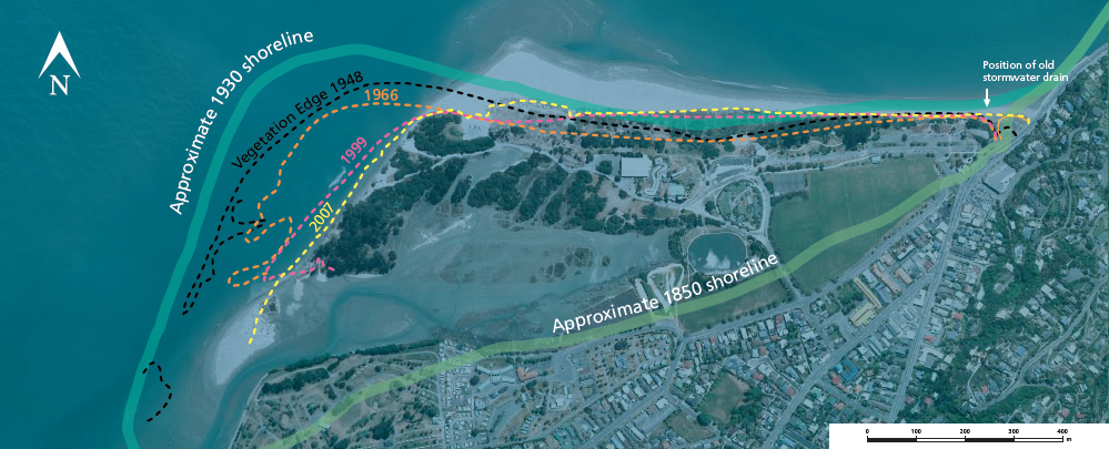
Since 1935 it has been possible to record vegetation lines at the beach using aerial photography. The Blind Channel has been moving eastwards at an estimated average rate of 3.85 metres per year. Vegetated dunes that once provided some protection for the Motor Camp have eroded. The central front beach has been through a period of erosion and sand-building while the eastern-most area has been through several periods of change. In 2005 the stormwater outlet at the eastern end of the beach was realigned and the concrete seawall modified to absorb wave energy. These engineering changes combined with planting native spinifex and pingao sand-binding plants has encouraged the re-establishment of sand dunes along this part of the beach.
What is Coast Care?
Coast Care is a community based programme which aims to protect the natural coastal environment. It is made up of volunteer groups such as beach users, schools and residents who wish to be actively involved in managing and protecting Tāhunanui Beach. The programme was supported by the Nelson City Council who gave professional advice and supplied resources such as materials for pedestrian walkways, labour and plants.
“An important aspect of Coast Care is recognising that sand dunes are dynamic. To achieve the best result the programme has to work with nature to ensure that any sand lost through wind and wave action is replenished by sand trapped by native sand-binding plants. The programme has trialled different techniques for protecting the sand dunes and different planting techniques have been used to get the best results. It has been an ongoing learning process, specific to Tāhunanui Beach. It is hoped that with increasing knowledge and experience, this will help the beach remain as natural as possible, for everyone to enjoy.”
Planting
Native sand-binding plants are used to help build dunes. Successful species planted to date include pingao Desmoschoenus spiralis and spinifex Spinifex sericeus. Pingao, once common all around New Zealand’s sandy shores, has a strong and spreading root system that helps stabilise dunes. Introduced marram grass has largely displaced pingao; marram is a tough survivor but does not bind and help build sand dunes as successfully as pingao and is prone to undermining during storm events.
Fenced boardwalks
For native sand-binding plants to trap sand they must provide good ground cover and be healthy and strong. Fenced boardwalks are provided to encourage you to keep off the dunes in areas where we are trying to help dune building in these planted areas.
What of the future?
The current beach was formed in 1875 following the collapse of the Waimea Sand Bank in Tasman Bay. Previously Tāhunanui Beach was a gravel and boulder beach along what is now Beach Rd. Over the past 60 years the eastern movement of The Blind Channel has washed away some 250 metres of the western end of the front beach. But whether this is a constant trend isn’t known. The sea and its dynamics are always changing.
We known the quantity of sand that moves around Tasman Bay, most of which eventually ends up to the south of the Waimea Estuary, is increasing. So any erosion that does occur at Tāhunanui Beach is localised repositioning of the sand within the stockpile.
In the future there will still be a beach at Tāhunanui, but no one knows exactly what position it will be in, or what it will look like.
This information was written for the Nelson City Council Heritage plaques at Tāhunanui Beach.